Maps are at the core of any Wildland Search and Rescue (WiSAR) operation. Go to https://sargis.napsgfoundation.org/ to find out more about how you can get started using GIS for search and rescue.
This site is currently UNDER CONSTRUCTION. b3de is content aggregator mobile friendly website that presents content made available by your favorite sources ( and even some you've likely never heard of ) via really simple sindication and web syndication.
Here are some simple instructions for the Mountain Rescue Association that shows how your team can embed a simple map of your recent missions into your team website.
1) Contact your webmaster and ask them if they can embed content using an "iframe".
2) Go to the Mountain Rescue Association Homepage at www.mra.org.
3) Open the MRA Mission Data Dashboard.
4) Zoom into your response area using your mouse wheel, zoom buttons, or hold shift + left click to draw a "zoom box".
5) Click the Share Button and then the "Embed map" button and copy the "code".
6) Send to your webmaster so they can embed it in your website!
After a few years of teaching how to deploy MapSAR Online,Alix Vezina and I decided it was time to open up the no-cost training to a much wider audience.
In this lesson, you'll create a web map to prepare data for search operations. Your map will contain static base data showing regional boundaries and key features, as well as editable layers that can be changed as an incident develops. Then, you'll use the map to create a web app that even non-GIS professionals can use. Finally, you'll use the app to track a fictional SAR mission.
We worked with the Learn ArcGIS team to produce a lesson that walks you through the following steps:
Use the app to map a fictitious search and rescue operation as it happens.
1 hour 15 minutes
This will give a GISprofessionala basic understanding of search and rescue OR a SAR professional a basic overview of how ArcGIS Online works. The app you create is using Web AppBuilder for ArcGIS.
On November 6-8, 2017, NAPSG Foundation's Search & Rescue GIS Working Group gathered with more than 50 Search & Rescue (SAR) leaders and GIS responders at the Esri Office in Broomfield, Colorado, for the highly anticipated 9th Annual Search & Rescue GIS Workshop. All resources (training, presentations, videos, etc.) have been made available here from the NAPSG Foundation website: SARGIS9 Website The purpose of the SAR GIS Workshop was to build capacity and advance the use of location and analytics-based decision support tools across the SAR community for missing persons and disaster SAR. The diversity of perspectives and experiences generated a rich dialogue around challenges and potential solutions.
Presentations
We had a diverse array of presentations from across Local, State, Federal, and Volunteer organizations.
I've got Drones�now what? Emerging patterns of UAS in SAR [PDF]
MapSAR Online
MapSAR has been a great ArcGIS Desktop (ArcMap) tool for the past decade. However, we recognize the need for easier to use tools that can be used to collaborate across organizations. That is why have started a new initiative called, MapSAR Online. MapSAR Online was used effectively at SARGIS9 and everyone left with the capability of providing their team with a situational awareness viewer. Here is the app we used for training - each person created a quick hasty map for their area of responsibility and learned how to build a similar app for their team. It was awesome to see the map light up with Incident Command Posts across the US within a minute of accessing the app!
As a result of this training and exercise, the SAR Working Group will be working hard to roll out MapSAR as a combined ArcGIS Pro, Online, and Field template for organizations who want to quickly get up and running with geospatial tools. In the meantime - see the training website for currently available resources.
Field Exercise
We also had an outdoor field exercise to test the concepts of using geospatial tools for planning, operations, field mobility, and situational awareness.This was also a great opportunity to work directly with software development staff at Esri to provide feedback on field apps like Workforce for ArcGIS.
Participant Map
This was the first time we had a combined wildland / urban search and rescue theme which allowed for greater collaboration and learning. Find out more about who was there and where they are from with this Story Map below (open in a new browser window if needed).
What can you do next to help your organization?
This basic training event was meant to give you an awareness of tools that are available and for you to self-assess your level of preparedness with geospatial decision support tools.
1 Complete a Self-Assessment - Use our beta-version Tool to self-assess your agency's geospatial preparedness, and help you measure and track your progress in building and maturing your GIS capabilities. (http://bit.ly/2e6Z9KB)
2 Adopt and Implement the US National Grid as a point and area reference system towards achieving consistent situational awareness across agencies and levels of government.
3 Use Standardized Incident Symbology and explore & use national infrastructure data available through HIFLD Includes standardized symbols for Search & Rescue.
4 Update or Develop GIS SOPs - Use the latest guidelines and templates to update or develop GIS SOPs for your agency to support effective incident management & coordination. (http://bit.ly/2daopgZ)
Conclusion
This was an extremely fun and rewarding event. Best of all, thanks to the NAPSG Foundation and Esri, it was provided free of charge to participants and everyone left with new capabilities regardless of skill level with GIS.
We would like to continue to host these events and provide tools like MapSAR - butwe need your help! While our target audience has always been field practitioners and GIS Specialists, we need buy-in from decision makers to further invest in the use of geospatial tools for SAR. Here are some ways you can help. 1) Host a local event using the free training materials. Stay tuned for more details on SARGIS10 and MapSAR development!
2) Speak with your County / State SAR Coordinator about the importance of geospatial tools in all aspects of search and rescue (Presentation). 3) Join the SARGIS Community!
The NAPSG Foundation Search & Rescue (SAR) Working Group is pleased to announce our 9th Annual SAR and GIS Workshop! Join us for this annual opportunity that brings together professionals from diverse backgrounds, "so that others may live..."
What is SAR? Search and Rescue with a focus on missing person search and wildland rescue. What is GIS? Geographic Information Systems - "data you can see on map".
The primary audience will be SAR Personnel and GIS Specialists who are interested in Public Safety. We especially encourage National Park Service, FEMA USAR, and Mountain Rescue Association Team members to participate!
Workshop Agenda:
Day 1 - Geospatial Concept of Operations for Search & Rescue
Presentations
Panel Discussion
Lightning Talks
Day 2 - Geospatial Decision Support Tools (Basic & Intermediate tracks)
Paper Maps
US National Grid
Spatial Analyses
Field Apps
Web Maps and Apps
Basic Track: Participants will learn how GIS can be applied to SAR and will practice using already built geospatial decision support tools.
Intermediate Track: Participants will be introduced to SAR concepts, and they will incorporate existing GIS knowledge to create geospatial decision support tools.
Day 3 - More Training & Testing
Participants will complete the training tutorials and practice using geospatial tools for an instructor "Stress Test". Also, participants will have the chance to self-assess their capabilities and readiness.
Pre-requisites:
Basic Training participants(SAR Practitioners) must complete the following short and self-paced tutorial before SARGIS9: Get Started with ArcGIS Online (AGOL)
Intermediate Training participants (GIS Practitioners) participants must complete the following short and self-paced tutorials, or have equivalent knowledge before SARGIS9:Get Started with ArcGIS Pro and Get Started with ArcGIS Online
Approval Process for Participants:
While this is a no-cost event, a total of 60 registrants will be selected. and would like to have approximately 50% SAR Practitioners (Basic Training) and 50% GIS Practitioners (Intermediate Training) who can commit to completing the pre-requisite training.
On February 8th, 2017 the NAPSG Foundation provided a virtual workshop for the Montana Association of Geographic Information Professionals (MAGIP) and local search and rescue team members. While MAGIP attendees attended on-site (Bozeman, Montana), they also extended the invitation to the Public Safety GIS and SAR Community to attend via WebEx. You can watch this presentation here via WebEx video. The objective of this presentation was to foster exchange between the Geospatial Professional and Search and Rescue Communities by providing an overview of capabilities with geospatial decision support tools and building a common language. We feel we have achieved this objective. As a result of this event, the local SAR Teams and GIS Professionals plan to meet more regularly, share data, and train on using geospatial decision support tools for search operations. In addition, the audience agreed they would like to participate in future SARGIS workshops, including the 9th Annual Search and Rescue GIS Workshop (SARGIS9 - November 2017, Rocky Mountain Region).
Resources
We used the SARGIS8 Training Story Map to guide the presentation and discussion. This website includes downloadable tutorials and interactive examples to show your local SAR Team. You can access this free training resource here: http://bit.ly/BasicSARGIS
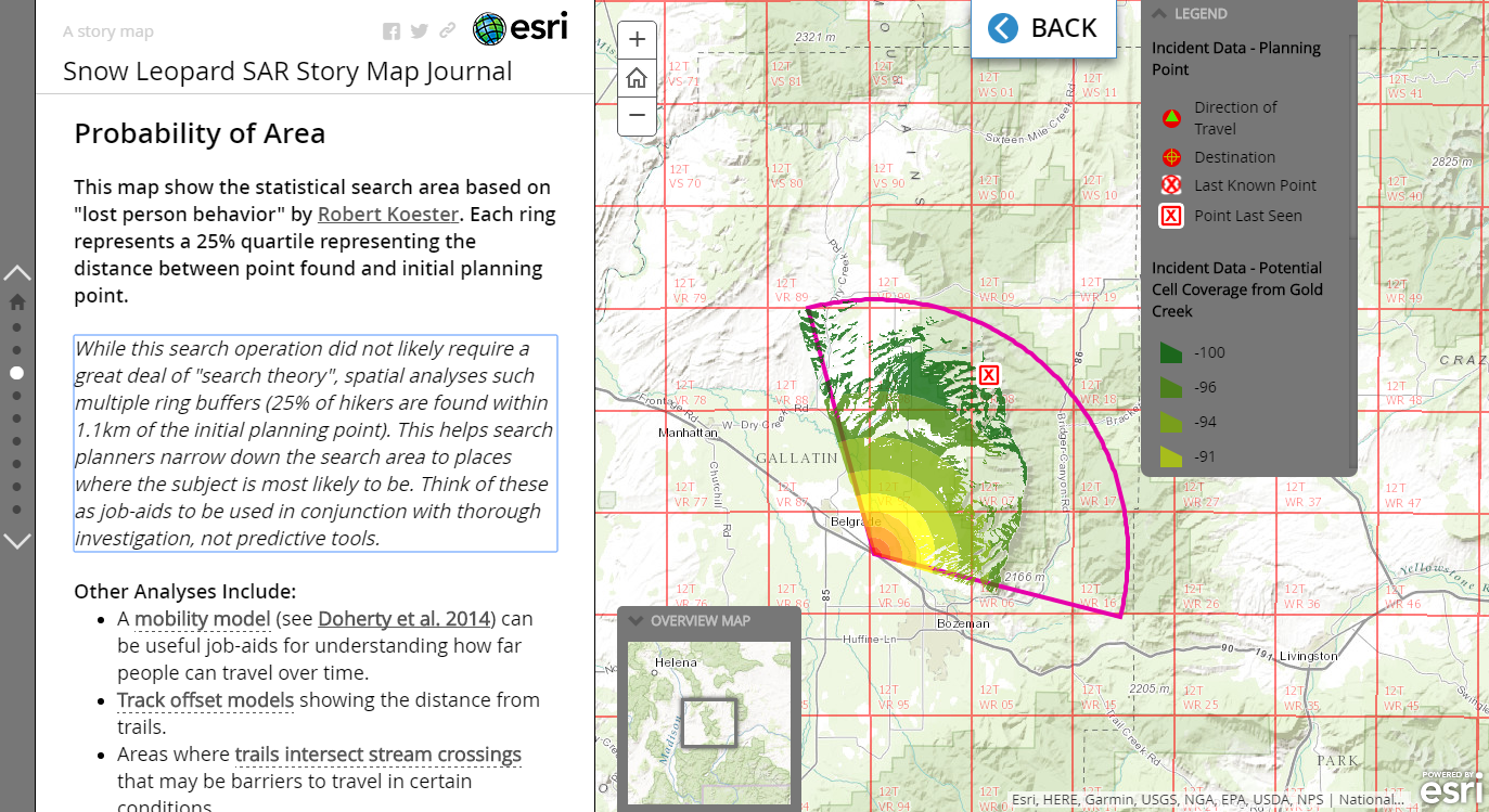
In addition, the case-study we used to kick-off the event was based on a group of photographers who were stranded in the mountains north of Bozeman, Montana. Geospatial intelligence was critical in this mission and the Story Map allows us to review the mission and learn from it. You can access this interactive Story Map here: http://arcg.is/2lmtuaC
For information about GIS for Search and Rescue and to begin developing geospatial decision support tools for your SAR Team, see the Wilderness Search and Rescue Capability and Readiness Assessment Tool (CARAT). Special thanks to Curtis DeVault of MAGIP, Angela Perv�l of NAPSG Foundation, and Don Ferguson SARWG Co-chair for helping to make this event possible despite my crazy schedule and presenting remotely from New Zealand.
Here in New Zealand we have had a few especially strong wildfire events. One, the Port Hills fire burned in the wildland urban interface and led to damaged structures and evacuations. This is common in the US and Australia but much less so here in the more temperate and moisture rich islands. As such, fire and emergency management agencies are only just beginning to realize the importance of public information maps in these situations. Fortunately, Canterbury Maps, the GIS Team at Environment Canterbury were able to step in on their first day of activation and stand up a Public Information Map for the community. They did this using WebGIS via ArcGIS Online. This map is cloud-hosted and able to handle the heavy load of viewers in emergency situations. Radio New Zealand was the first to pick this map up and share authoritative information in an article and they deserve recognition as well. Well done to all involved - especially the first responders doing their best to protect lives and property.
From November 14th through the 16th, 2016 the National Alliance for Public Safety GIS (NAPSG) Foundation brought together more than 75 of the Nation's Search & Rescue (SAR) leaders and GIS professionals for the 8th annual Search & Rescue GIS Workshop. The content available should be of interest to anyone interested in maps, GIS, public safety, or search and rescue so please do share. To see the website with full links to the agenda and presentation go to: http://bit.ly/2hdPxCx To access our SARGIS Basic Training Website go to: http://bit.ly/BasicSARGIS
The National Alliance for Public Safety GIS Foundation's Search & Rescue GIS Working Group is hosting the 8th Annual SARGIS Workshop and Meeting on November 14th-16th, 2016. Cost - Free! **Space is limited** Training and workshop materials will be provided at no cost. Location - USGS: 12201 Sunrise Valley Dr, Reston, VA 20192 What is it about? SARGIS8 will focus on the capabilities and best practices for Search & Rescue and geospatial technologies with 2 days of hands-on training.
Day 1: Monday - Plenary for SAR and GIS practitioners: Keynotes, presentations, & panel discussions (space is limited to 120 participants)
Day 2: Tuesday - Two tracks of technical GIS training (Basic/Web GIS & Advanced/Desktop GIS - space is limited to 60 participants)
Day 3: Wednesday - Two tracks of technical GIS training, culminating in a joint table-top exercise (space is limited to 60 participants)
Who should attend? Search and Rescue Personnel (paid and unpaid) who want to know more about GIS for SAR GIS technical professionals & staff that currently support SAR missions and/or are interested in learning how they can help SAR teams Other Public Safety Operators, Decision makers, & Policy makers Why Participate? Join leading local, state, and Federal public safety agencies that are charting new ground for how GIS can be applied to missing person incidents. Go to this Registration Page for more details and to lock in your place at this event.
Four new SpatiaLABS are now available using Search and Rescue in Yosemite National Park as their topic. These are FREE and ideal for beginners to geographic information systems (GIS), search and rescue professionals, or even GIS Specialists who are new to ArcGIS Pro or ArcGIS Online. In the first of these four labs, you will use search and rescue incident locations to create an interactive web map and web mapping application in ArcGIS Online to explore the distribution of incidents in Yosemite National Park.
In order to try these tutorials you will need access to ArcGIS. First of all, if you work for a government agency or are a University Student, you most likely have access to ArcGIS so check with your IT or GIS Administrator. If not, here are some other options:
For University instructors - SpatiaLABS are designed to freely modified to fit your needs.
"You'll find instructional materials in Microsoft Word and other common formats. Go ahead, change or add self-assessment questions, tweak the context for the analysis, rework the lab to use local data. Customize SpatiaLABS to suit your non-commercial needs." Special thanks to the SpatiaLABS team and Joe Kerski for his post on these SpatiaLABS.
This month we had some audio issues with our Google Hangout, but I did go back and record my Snap2Map Demonstration embedded below. Snap2Map is a really simple way to make a map with interactive geo-tagged photos. This can be used for a wide variety of applications. For SAR the use-case we are exploring with the YSAR Tauranga is using the Map Tour to create SAR PrePlans. A Map Tour could include photos and videos to highlight:
Hazards in an area
Landing zones for helicopters
Missing "decision points" on a trail
Any intelligence that you would like to capture with a map and photo!
Here is the free Snap2Map Tutorial by Jennifer Lentz if you would like to get started. It walks you through the following steps.
setting up and logging into an ArcGIS Online (AGOL) account
downloading Esri's free Snap2Map app (available for free on Android and Apple-based smart devices)
downloading a GPS tracking app (optional)
Connecting your Snap2Map app to your organization's AGOL account
Selecting the geo-tagged photos you'd like included in your story map, and publishing them to the story map through the Snap2Map app
Editing your story map on a computer, including changing the basemap, color scheme, etc.
saving the story map
editing the information provided in the "details" page of the Web Map, including change the thumbnail image, and sharing preferences
adding tracking data to your story map (optional)
viewing the finished Story Map
Thank you to YSAR Tauranga for the inspiration - I look forward to seeing your end product and seeing if any Mountain Rescue Association Teams pick this up and try it out.